OFCAWS
OFCAWS is a browser-based mapping application that uses maps from various providers: Ordnance Survey, Google, Open Street and others.
OFCAWS was made publicly available in August 2020 and is written by Ray Crowther.
OFCAWS is available to subscribing users and most proceeds are donated to charity.
Register for a Free Trial.
Contact Email: feedback@ofcaws.ity.me.uk
History & Features
The core of the application has been used for 8 years in the Table-Top Rallying website.
As a private, standalone mapping tool it has been used for route planning, rallying and geocaching. This public version was released in August 2020 and most subscription fees are being donated to charity.
In July 2020 Ordnance Survey rolled out its new digital map series (OS Data Hub), and OFCAWS was
one of first applications to use this technology.
OFCAWS has access to the full set of current UK OS 1:50000 and 1:25000 maps,
as well as map layers that zoom into street and building detail.
Map sets from other providers are also included such as Google Road,
Google Satellite, Open Street and specialist maps for cyclists, railways and history.
Features within OFCAWS include the ability to search for place names, postcodes and
points of interest, and EV charging points; find locations from map references, latitude/longitude and what3words;
add markers to the maps; use Google street view; the import and display of files
containing routes and geocaches;
saving and printing map extracts; a magnifying window to examine map details (Spy); and
a measuring tool (Roamer).
The application will be a valuable tool for anyone that uses UK or World maps on a regular basis.
For geocachers, geocaches can be imported from GPX, GSAK and Pocket Query files.
Cache-type markers are placed on the displayed map, which when clicked will display the cache details and logs.
Screen and printed reports from the cache list are also available. There is a also a co-ordinate conversion tool. Linkage with
a geocaching.com account allows the extraction of personal notes and corrected coordinates for display, which can be
added to an updated GPX for download to your GPSr.
Direct access is available to geocaching.com when searching for caches or
adventure labs in an area or close
to an OFCAWS designed route. Such caches may be added to a geocaching.com List.
The OFCAWS Help File provides greater detail.
A FREE 24-hour trial is available by clicking OFCAWS. Thereafter a subscription for a year is £25 (minimum). Just £5 goes to maintaining and enhancing OFCAWS, BUT, the remainder is donated to charity directly by the subscriber.
Your donation will add to the £42,000+ that has been donated to Cancer Research, Alzheimer's Society, Multiple Sclerosis Society, MacMillan Cancer Support, Motor Neurone Disease Association, NHS Charities Together and others since 2004.
Version History
| Version | Changes |
|---|---|
| 1.9600 | * Reorganisation of Map Menus.
* Several new map types added. * Caching of map tiles and external calls. * Rewrite of W3W processes. * Fixing of minor display problems. |
| 1.9200 | * More tidy-ups and tweaks following a code scrutiny by Copilot. |
| 1.9000 | * Lots of tidy-ups and tweaks following a code scrutiny by Copilot. |
| 1.8500 | * What3Words is available in all supported languages.
* Searching for caches can now be filtered by geocache owner. |
| 1.8300 | * Removed NCR EV Charging Points as no longer available. |
| 1.8200 | * Added conversion to/from RD(Dutch) and Cartesian Coordinates.
* Changed Route Marking selection process. |
| 1.8000 | * Searching for caches can now be filtered by geocaching name. |
| 1.7500 | * Searching for caches can now be filtered by geocaching types.
* Additional maps from Esri have been integrated. * The map list now contains external links to Essex PROW and footpaths maps, and the government MAGIC maps. |
| 1.7100 | * Location displays for UK maps now include Landranger and Explorer map numbers.
The extent of these maps can also be shown via a new OS Map Extent option on the Map Tools tab. |
| 1.7000 | * Adventure Lab caches can be accessed directly from geocaching.com by searching in an area or close to a route. |
| 1.6100 | * Added Reverse Wherigo to Coordinate Conversions. |
| 1.6000 | * Geocaches can be accessed directly from geocaching.com
by searching in an area or close to a route.
* Corrected co-ordinates may be imported from a third-party GPX . |
| 1.5200 | * A Route can now be downloaded as a (Garmin) Track. |
| 1.5100 | * A marker projection may now be in Kilometres, metres, Miles or feet. |
| 1.5000 | * Added more HERE maps.
* Added experimental mapping of EV Charging locations. * Better support for touch screen devices. |
| 1.4600 | * Added ability to change the title, colour and number of a marker. |
| 1.4500 | * Added several historical maps.
* Map selection now spread over two columns. |
| 1.4100 | * Added Straight Line Routing option and sample.
* Some menu items renamed. |
| 1.4000 | * Upload and handling of geocache GPX files significantly changed. Uploaded
files are now stored individually and can be recalled when necessary. When
geocaching.com is accessed while uploading these files the content is enhanced
by the addition of corrected coordinates and user notes. These enhanced files can
be downloaded for your GPSr to improve the visualisation of cache icons on your GPSr maps.
* Added ability to download a Route as a GPX file for export to another system. |
| 1.3000 | * Removed Pluscode and Mapcode coordinates from pop-ups.
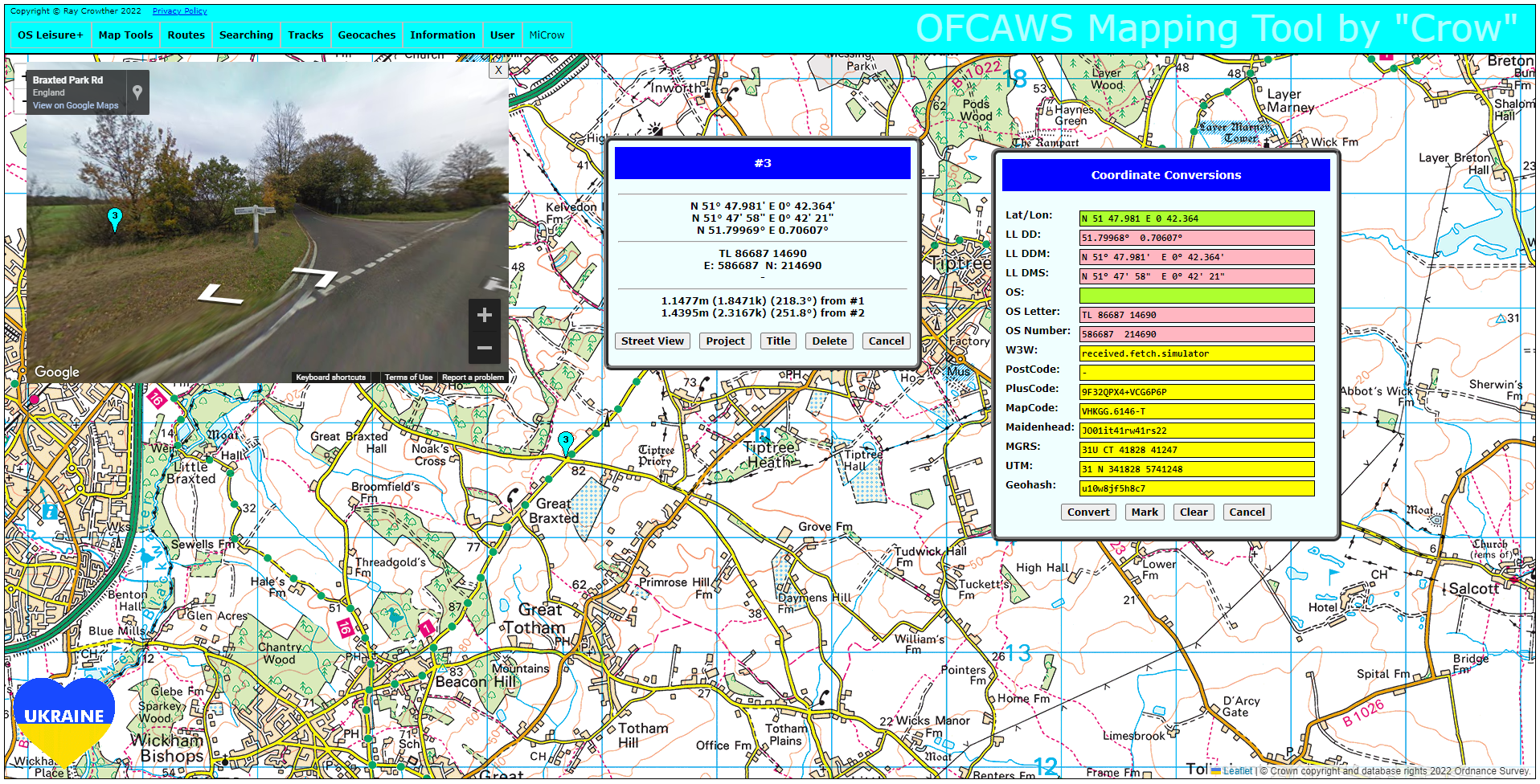
* Added ability to project a new marker by distance and (true North) bearing from a marker window. * Link to MiCrow changed to facilitate future enhancements. Standalone Microw now accessed as OFCAWS-MICROW.php. * Searching by Ordnance Survey (by default) looks for UK place names or post codes. There is a now the ability to search for any of the entities in the OS gazetteer. * A Coordinate Conversion tool has been added which permits conversion between any of these mapping schemes: Latitude/Longitude (decimal degrees), Latitude/Longitude (decimal minutes), Latitude/Longitude (degrees/minutes/seconds), OS Grid (Letters), OS Grid (Numbers), What3Words, PostCode, PlusCode, MapCode, Maidenhead, MGRS, UTM and Geohash. The position may be marked on the map. |
| 1.2400 | * Resolved problem with SCREEN capture. |
| 1.2300 | * Popups re-designed.
* Inter-marker (true North) bearings now displayed in marker window. |
| 1.2200 | * Added Thunderforest and HERE mapsets.
* Pluscode and Mapcode processing and display. |
| 1.2100 | * Changes to registration and re-registration procedures.
* Postcode lookups. |
| 1.2000 | * Default Routing Engine changed from Google to TomTom.
* Relabelled some of the drop-down menus. |
| 1.1200 | * Removed obsolete OpenSpace maps.
* Added Tramlines and Hide/Show Dots for Tracks |
| 1.1100 | * Added OS Vector Tile & OS Zoomstack mapsets. |
| 1.1000 | * Route Marking menu & facilities |
| 1.0700 | * Changes to allowed TRK formats
* Smoother layer transitions on OS Leisure + maps |
| 1.0602 | * Added animated scale
* Menu Scale On/Off |
| 1.0600 | * Added BING maps to mapsets. |
| 1.0500 | * A single uploaded Geocache GPX file can now be saved for later retrieval. A future
change will allow the saved geocaches to be displayed in OFCAWS-Microw.
* Because of the number of additional geocaching options there are now separate Geocaches and Tracks dropdown menus. * OFCAWS-Mini has been renamed to OFCAWS-Microw. |
| 1.0400 | Uploaded Geocache GPX files can now be updated to include corrected coordinates and personal notes, then downloaded for transfer to a GPSr. |
| 1.0310 | A few bug fixes. |
| 1.0300 | * Optimised connection to geocaching.com.
* Filters can now be applied to cache lists. |
| 1.0200 | * Major additional features for geocaching. Having loaded a GPX of geocaches it is
now possible to display and print a list showing the key
data. The printed list is a handy accompaniment for a geocaching walk. Furthermore, by connecting
OFCAWS to your geocaching account it is possible to supplement the data with user personal notes and
corrected co-ordinates, items which are not available from pocket queries.
See the Help file for detailed explanations. * As an aid to touch precision the pop-up menu in OFCAWS-Microw now contains buttons rather than links. * Inter-marker distances are now shown in miles and kilometres. * The Track display shows waypoints with distances from the start. * A distance measuring device (Roamer) is now available. |
| 1.0100 | A significant upgrade which includes: a menu-based navigation system for a cleaner interface because of the number of additional options; better support for mobile devices; an expansion of the TRK facilities due to major changes to OFCAWS-Microw; an updated Help file to describe the upgrade. |
| 1.0080 | * Additional TomTom Map
* Fractional Zoom: On some maps, a greater granularity of zoom levels * Boxed Zoom: Hold down the Shift key and drag a rectangle around the area you want to zoom into. *Mobile hold-finger for a pop-up menu of options. |
| 1.0070 |
OFCAWS-MICROW is now available. It is a cut down version of OFCAWS for simply tracking your location and will run in a browser on your phone or tablet.
You access OFCAWS-MICROW by simply going to https://ofcaws.ity.me.uk or via the new . MICROW will only work once you have an encrypted cookie - see 1.0065 below. There are simple controls on the map: a Zoom In /Out top left, a top right. The Map button (currently) toggles between an Open Street map and Ordnance Survey Leisure map. will launch the main application. A pulsing blue circle indicates your position on the map. It is intended to upgrade MICROW to a native Android and IOS app in the future. |
| 1.0065 | At your next Login, an encrypted cookie will be stored containing your UserName and Password. On subsequent Logins the login process will be automatic unless you have changed your password. |
| 1.0060 | * Access to the OFCAWS Page.
* When a new version has been uploaded the version history from the web page will automatically be displayed. * to report problems or make suggestions. * Holding the Ctrl key when you click will capture the full displayed map. * Addtional Esri Road Map, Esri Topographic Map. * Import of TEN files. will load the overview map of the La Slog table-top rally. * Forgotten Password handling. * To start OFCAWS now go to: https://ofcaws.ity.me.uk/OFCAWS.php * Blank tiles may appear on OpenSpace maps due to an issue at Ordnance Survey. |
| 1.0050 | Interface Revisions |
| 1.0040 | Additional Map Sets |
| 1.0030 | Screen Save and Print |
| 1.0020 | Spy Feature |
| 1.0010 | Import of GPX and TRK files |
| 1.0000 | Original - 12 August 2020 |
Statistics
Total Income for Charity: £2744.05
Total Active Subscriptions: 63
Total User Sessions: 20517
Technical
The OFCAWS client is written in Javascript with libraries from Leaflet, Ordnance Survey, Google, What3Words and others.
Host processing is via PHP using MySQL Databases.
Author
Ray Crowther was born in London and now lives in Tiptree, Essex.
He read Cybernetics and Mathematics at Reading University and then developed computer systems in England and Germany before starting his own company specializing in human resources software.
During his systems career he had technical papers published and wrote more reference manuals than he can remember.
He maintains that the exacting discipline of technical authoring prepared him well for a creative change into fiction writing.
Ray has had four novels published: The Nearest FarAway Place, Panglossian, Schoolfrenz and Thalamorph. Details can be found at his Author's Web Site.
When he is not writing software or novels, Ray can be found walking and jogging his local lanes and footpaths,
cycling, geocaching (under the pseudonym of "Mr Crow"), competing in motor rallies ("Crow"), and organizing table-top rallies.